


Our Journey: 2021
Back to the Saronic Gulf: (Augustus-September 2021)
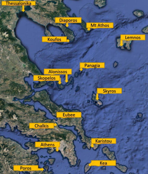
In order to go to our winter berth in Kalamata (South of the Peloponnese) we still had to sail over 416 miles (770km). We therefore decided to make multiple stops as we had time. Our first
stop after mont Athos was the island of Lemnos (also called Limnos). This island located to the
east of Athos and close to the Turkish border is very exposed to the Meltemi, so we had to
wait for a calm sea to sail to Lemnos. The harbor of Lemnos offers good protection but has a
limited number of spaces. We were lucky as when we arrived a boat was leaving so we could
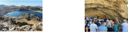
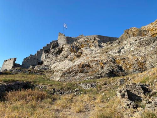
berth the boat immediately. The harbor is located in a bay with an old fortress on the northern
side. For us it
was important to be in Lemnos after the 15 of August as we had an appointment for our second
Covid shot. The island of Lemnos has several bays on the southern side offering good shelter.
It is there that in 1915 and 1916 the English and French navies started twice to attack the
Ottoman army ( now Turkish) in the Dardanelles, also called The battle of Gallipoli. It was a
terrible defeat for the British and French Navies. As we had a few days to wait for the jab, we
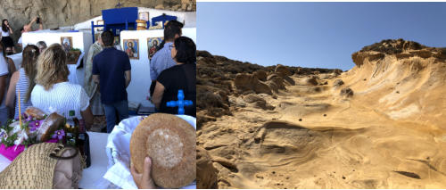
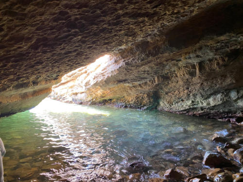
decided to visit the island. The first place was a chapel built into a natural cave. The chapel of
Panagia Kakaviotissala is located high up in the mountain and the road stops about 1km from the
chapel. You need to walk for about 20 minutes before you reach the place. The view is very
rewarding as on one side you can admire the sea and on the other side you can see that a lot of
land is used to harvest agricultural products in the early months of the year when the rain is
abundant. If you want to visit the site, I recommend that you do so in the late afternoon
because the light is better. After the chapel we moved to the little harbor of Nea Koutali. This
place was home for a little flotilla of boats harvesting sponges. Today the EU community has
started some construction works to allow a few sailboats to dock. In the centre of the village
there is a little museum dedicated to sponge harvesting. The museum is small, but it allows you
to realize how the sponges were collected and prepared for the trade. After this little visit,
we moved to Moudro. This harbor is much bigger, but still difficult to access for sailboats as
the maximum depth is only around 2 meters. We met a few people that had been living in this
harbor for quite a long time despite the lack of infrastructure nearby. If you stay in this
marina you definitely need a motorbike or car to buy
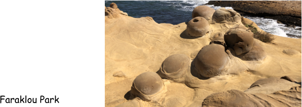
groceries. We then continued our trp towards Falakro cape on the northern shore. This side is
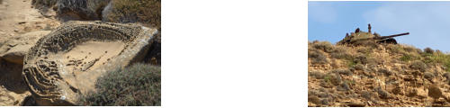
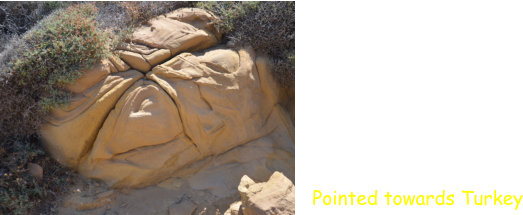
fully exposed to the Meltemi winds which over time have sandblasted the rocks. The landscape
is very special and looks like a lunar landscape. Other parts look like waves etc…. From there you
can see the Turkish Island of Gockceada located 11 miles away. In one place there is an old tank
with it’s gun aimed at Turkey. The symbol is quite clear. Further to the East, there are
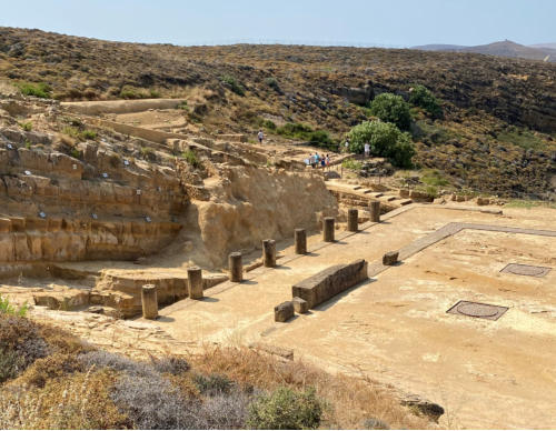
numerous archeological sites. Some of them can be dated to as far back as 12 centuries before
Christ. We visited the site of Kabeiroi where a few columns remain. At sea level below the
temple there is a cave that is difficult to access. It is the place where Philoctetes (the son of a
Greek king participating in the Trojan war) was dropped by the Greeks on their way to Troy. On
the way to Troy, Philoctetes had been badly bitten by a snake and he stayed in the cave for
nearly 10 years to
treat his wound Once healed, the Greeks came back to pick him up and his contribution allowed
the Greeks to win the Trojan war. We were disappointed by the archeological site and did not
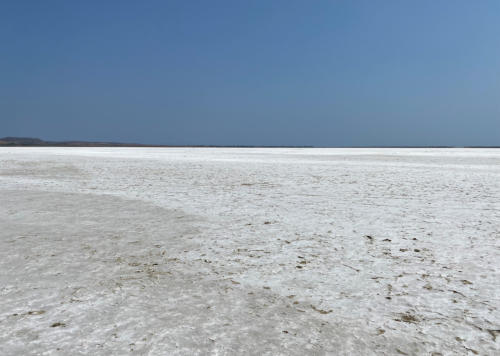
visit other sites. On the way back, we passed lake Aliki. This lake is separated from the sea by
beaches. In the winter when there is plenty of rain, the lake looks like any other lake. In the
summer, the lake is dry and leaves a salt crust of a few cm. The lake has a surface area of 1600
acres (650ha). During the winter, a large population of flamingos and other birds stays there
for the winter. The whole lake is a nature reserve. Finally, on the 22nd of August, the Meltemi
decided to go down and we decided to continue our navigation and this time the target was the
island of Skyros. This island is located between Euboea and Lemnos. The distance from Lemnos
is around 75 miles so we left our mooring at 5:30 in the morning. We had been told that the
harbor was special and when
we arrived, the harbor master helped us to moor the boat very securely. The reason became
clear in the evening as we realised that the ferry was coming and it stopped less than 20
meters away from the boat. If we had not been moored securely, the water pushed by the
propeller of the ferry could have crushed the boat against the wall. The marina is also known
for disco music in the showers in the evening. Skyros island is important, but a large part of it
cannot be accessed as it is a military area. The other part was not accessible to us as a
precaution against fires. So we could only visit a small part of the island. North of the island
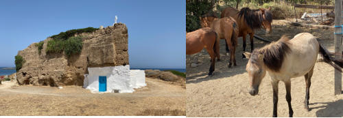
there is a chapel built into a rock. It is very small and closed but the fact that the chapel was
built into the rock is an indication of the religious faith. The other attraction of the island is
the skyros horse. It is a unique breed of horse that is the size of a pony but looks like a horse.
This breed is highly protected as the species is endangered with only 200 horses living today. A
few have also been moved in Scotland to protect the species. Those horses are very docile and
during the summertime they are used by farmers to help with the harvest. In the winter they
are free to roam. The horses can be seen in a farm that has around 30 horses. In the farm,
children can come in the morning and ride on the horses. After 2 days in Skyros, we moved to
Karystos, a city located south of Euboea. The trip was a little bit complicated as the current
and the wind were against us between Andros and Eubée. Once we had passed the two islands,
the conditions improved and we reached Karistou without any hassle. After one night, we left
Karistou to the south and stopped in a northern bay of Kea island followed the following day by
a journey to Poros.
over 416 miles (770km). We therefore decided to make multiple stops as we had time. Our first
stop after mont Athos was the island of Lemnos (also called Limnos). This island located to the
east of Athos and close to the Turkish border is very exposed to the Meltemi, so we had to
wait for a calm sea to sail to Lemnos. The harbor of Lemnos offers good protection but has a
limited number of spaces. We were lucky as when we arrived a boat was leaving so we could
berth the boat immediately. The harbor is located in a bay with an old fortress on the northern
side. For us it
was important to be in Lemnos after the 15 of August as we had an appointment for our second
Covid shot. The island of Lemnos has several bays on the southern side offering good shelter.
It is there that in 1915 and 1916 the English and French navies started twice to attack the
Ottoman army ( now Turkish) in the Dardanelles, also called The battle of Gallipoli. It was a
terrible defeat for the British and French Navies. As we had a few days to wait for the jab, we
decided to visit the island. The first place was a chapel built into a natural cave. The chapel of
Panagia Kakaviotissala is located high up in the mountain and the road stops about 1km from the
chapel. You need to walk for about 20 minutes before you reach the place. The view is very
rewarding as on one side you can admire the sea and on the other side you can see that a lot of
land is used to harvest agricultural products in the early months of the year when the rain is
abundant. If you want to visit the site, I recommend that you do so in the late afternoon
because the light is better. After the chapel we moved to the little harbor of Nea Koutali. This
place was home for a little flotilla of boats harvesting sponges. Today the EU community has
started some construction works to allow a few sailboats to dock. In the centre of the village
there is a little museum dedicated to sponge harvesting. The museum is small, but it allows you
to realize how the sponges were collected and prepared for the trade. After this little visit,
we moved to Moudro. This harbor is much bigger, but still difficult to access for sailboats as
the maximum depth is only around 2 meters. We met a few people that had been living in this
harbor for quite a long time despite the lack of infrastructure nearby. If you stay in this
marina you definitely need a motorbike or car to buy
groceries. We then continued our trp towards Falakro cape on the northern shore. This side is
fully exposed to the Meltemi winds which over time have sandblasted the rocks. The landscape
is very special and looks like a lunar landscape. Other parts look like waves etc…. From there you
can see the Turkish Island of Gockceada located 11 miles away. In one place there is an old tank
with it’s gun aimed at Turkey. The symbol is quite clear. Further to the East, there are
numerous archeological sites. Some of them can be dated to as far back as 12 centuries before
Christ. We visited the site of Kabeiroi where a few columns remain. At sea level below the
temple there is a cave that is difficult to access. It is the place where Philoctetes (the son of a
Greek king participating in the Trojan war) was dropped by the Greeks on their way to Troy. On
the way to Troy, Philoctetes had been badly bitten by a snake and he stayed in the cave for
nearly 10 years to
treat his wound Once healed, the Greeks came back to pick him up and his contribution allowed
the Greeks to win the Trojan war. We were disappointed by the archeological site and did not
visit other sites. On the way back, we passed lake Aliki. This lake is separated from the sea by
beaches. In the winter when there is plenty of rain, the lake looks like any other lake. In the
summer, the lake is dry and leaves a salt crust of a few cm. The lake has a surface area of 1600
acres (650ha). During the winter, a large population of flamingos and other birds stays there
for the winter. The whole lake is a nature reserve. Finally, on the 22nd of August, the Meltemi
decided to go down and we decided to continue our navigation and this time the target was the
island of Skyros. This island is located between Euboea and Lemnos. The distance from Lemnos
is around 75 miles so we left our mooring at 5:30 in the morning. We had been told that the
harbor was special and when
we arrived, the harbor master helped us to moor the boat very securely. The reason became
clear in the evening as we realised that the ferry was coming and it stopped less than 20
meters away from the boat. If we had not been moored securely, the water pushed by the
propeller of the ferry could have crushed the boat against the wall. The marina is also known
for disco music in the showers in the evening. Skyros island is important, but a large part of it
cannot be accessed as it is a military area. The other part was not accessible to us as a
precaution against fires. So we could only visit a small part of the island. North of the island
there is a chapel built into a rock. It is very small and closed but the fact that the chapel was
built into the rock is an indication of the religious faith. The other attraction of the island is
the skyros horse. It is a unique breed of horse that is the size of a pony but looks like a horse.
This breed is highly protected as the species is endangered with only 200 horses living today. A
few have also been moved in Scotland to protect the species. Those horses are very docile and
during the summertime they are used by farmers to help with the harvest. In the winter they
are free to roam. The horses can be seen in a farm that has around 30 horses. In the farm,
children can come in the morning and ride on the horses. After 2 days in Skyros, we moved to
Karystos, a city located south of Euboea. The trip was a little bit complicated as the current
and the wind were against us between Andros and Eubée. Once we had passed the two islands,
the conditions improved and we reached Karistou without any hassle. After one night, we left
Karistou to the south and stopped in a northern bay of Kea island followed the following day by
a journey to Poros.